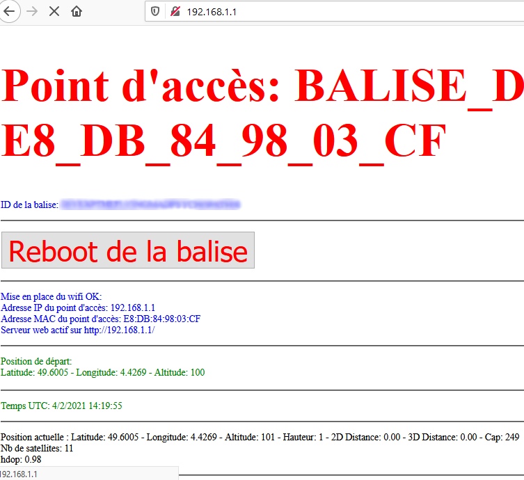
Je ne vois pas à quel endroit exact je dois indiquer le nom du point d'accès WIFI
Code : Tout sélectionner
/*
This program is free software: you can redistribute it and/or modify
it under the terms of the GNU General Public License as published by
the Free Software Foundation, either version 3 of the License, or
(at your option) any later version.
This program is distributed in the hope that it will be useful,
but WITHOUT ANY WARRANTY; without even the implied warranty of
MERCHANTABILITY or FITNESS FOR A PARTICULAR PURPOSE. See the
GNU General Public License for more details.
You should have received a copy of the GNU General Public License
along with this program. If not, see <https://www.gnu.org/licenses/>.
*/
/*
* Basé sur :
* https://github.com/khancyr/droneID_FR
* https://github.com/khancyr/TTGO_T_BEAM
*
* Adapté pour fonctionner avec un ESP01 (512k, 1M) et https://github.com/esp8266/Arduino
*/
// ======= Paramètres balise esp32 ** à modifier ** ============= //
/**
* [glow=red]Le nom du point d'acces wifi CHANGEZ LE par ce que vous voulez[/glow] !!!
*/
const char ssid[] = "ILLEGAL_DRONE_AP";
/**
* CHANGEZ l'ID du drone par celui que Alphatango vous a fourni (Trigramme + Modèle + numéro série) !
*/
// "000000000000000000000000000000" // 30 caractères
const char drone_id[31] = "ILLEGAL_DRONE_APPELEZ_POLICE17"; // si l'id est inférieur à 30 caractères, le compléter avec des "0" au début
// =========== Includes ======================= //
#include <ESP8266WiFi.h>
#include <SoftwareSerial.h>
#include "droneID_FR.h"
#include <TinyGPS++.h>
#define GPS_BAUD_RATE 9600 // ou 19200 avec refresh rate à 5Hz (le GPS doit stocker la configuration dans ce cas)
#define GPS_RX_PIN 0 // Brancher le fil Tx du GPS
#define GPS_TX_PIN 2 // pas utilisé
extern "C" {
#include "user_interface.h"
int wifi_send_pkt_freedom(uint8 *buf, int len, bool sys_seq);
}
// ========================================================== //
SoftwareSerial softSerial(GPS_RX_PIN, GPS_TX_PIN);
TinyGPSPlus gps;
droneIDFR drone_idfr;
// beacon frame definition
static constexpr uint16_t MAX_BEACON_SIZE = 40 + 32 + droneIDFR::FRAME_PAYLOAD_LEN_MAX; // default beaconPacket size + max ssid size + max drone id frame size
// beacon frame definition
uint8_t beaconPacket[MAX_BEACON_SIZE] = {
/* 0 - 3 */ 0x80, 0x00, 0x00, 0x00, // Type/Subtype: managment beacon frame
/* 4 - 9 */ 0xFF, 0xFF, 0xFF, 0xFF, 0xFF, 0xFF, // Destination: broadcast
/* 10 - 15 */ 0x01, 0x02, 0x03, 0x04, 0x05, 0x06, // Source
/* 16 - 21 */ 0x01, 0x02, 0x03, 0x04, 0x05, 0x06, // Source
// Fixed parameters
/* 22 - 23 */ 0x00, 0x00, // Fragment & sequence number (will be done by the SDK)
/* 24 - 31 */ 0x83, 0x51, 0xf7, 0x8f, 0x0f, 0x00, 0x00, 0x00, // Timestamp
/* 32 - 33 */ 0xe8, 0x03, // Interval: 0x64, 0x00 => every 100ms - 0xe8, 0x03 => every 1s
/* 34 - 35 */ 0x21, 0x04, // capabilities Tnformation
// Tagged parameters
// SSID parameters
/* 36 - 38 */ 0x03, 0x01, 0x06, // DS Parameter set, current channel 6 (= 0x06), // TODO: manually set it
/* 39 - 40 */ 0x00, 0x20, // 39-40: SSID parameter set, 0x20:maxlength:content
};
// Vérification ssid max 30
static_assert((sizeof(ssid)/sizeof(*ssid))<=32, "AP SSID should be less than 32 letters");
// Vérification drone_id max 30
static_assert((sizeof(drone_id)/sizeof(*drone_id))<=31, "Drone ID should be less that 30 letters !"); // 30 lettres + null termination
uint8_t program = 0; // 1: test beacon without GPS
char buff[5][256];
uint64_t gpsSec = 0;
uint64_t beaconSec = 0;
void setup() {
// start serial
Serial.begin(115200);
Serial.println();
// start WiFi
WiFi.mode(WIFI_OFF);
// set default AP settings
WiFi.softAP(ssid, nullptr, 6, false, 0); // ssid, pwd, channel, hidden, max_cnx,
WiFi.setOutputPower(20.5); // max 20.5dBm
softap_config current_config;
wifi_softap_get_config(¤t_config);
current_config.beacon_interval = 1000;
wifi_softap_set_config(¤t_config);
Serial.println();
Serial.println("Started \\o/");
Serial.println();
softSerial.begin(GPS_BAUD_RATE);
drone_idfr.set_drone_id(drone_id);
delay(5000);
}
/**
* Début du code principal. C'est une boucle infinie.
*/
void loop()
{
static uint64_t gpsMap = 0;
switch (program) {
case 0:
// Ici on lit les données qui arrivent du GPS et on les passe à la librairie TinyGPS++ pour les traiter
while (softSerial.available())
gps.encode(softSerial.read());
// On traite le cas où le GPS a un problème
if (millis() > 5000 && gps.charsProcessed() < 10) {
Serial.println("No GPS detected");
return;
}
// On traite le cas si la position GPS n'est pas valide
if (!gps.location.isValid()) {
if (millis() - gpsMap > 1000) {
Serial.print("Waiting... SAT="); Serial.println(gps.satellites.value());
gpsMap = millis();
}
return;
} else if (gps.location.isUpdated() && gps.altitude.isUpdated() && gps.course.isUpdated() && gps.speed.isUpdated()){
// On traite le cas où la position GPS est valide.
// On renseigne le point de démarrage quand la précision est satisfaisante
if (!drone_idfr.has_home_set() && gps.satellites.value() > 6 && gps.hdop.hdop() < 2.0) {
Serial.println("Setting Home Position");
drone_idfr.set_home_position(gps.location.lat(), gps.location.lng(), gps.altitude.meters());
}
// On actualise les données GPS de la librairie d'identification drone.
drone_idfr.set_current_position(gps.location.lat(), gps.location.lng(), gps.altitude.meters());
drone_idfr.set_heading(gps.course.deg());
drone_idfr.set_ground_speed(gps.speed.mps());
/*
float gps_time_elapsed = (float(millis() - gpsMap) / 1000.0f);
gpsMap = millis();
Serial.println(gps_time_elapsed,3);
*/
// Ici on affiche les données GPS pour sur le port Serie, toutes les secondes.
// Décommenter ce block pour voir les informations détaillées sur le port série
/*if (millis() - gpsMap > 1000) {
Serial.print("LAT="); Serial.print(gps.location.lat(), 6); Serial.print(" LONG="); Serial.print(gps.location.lng(), 6);
Serial.print(" ALT="); Serial.print(gps.altitude.meters()); Serial.print(" SAT="); Serial.print(gps.satellites.value());
Serial.print(" DOP="); Serial.print(gps.hdop.hdop()); Serial.print(" DISTfromLAST_POS_Sent="); Serial.println(drone_idfr.get_distance_from_last_position_sent());
gpsMap = millis();
}*/
}
break;
case 1:
// Envoi données GPS de test
drone_idfr.set_current_position(43.1234, -0.1234, 223);
drone_idfr.set_heading(234);
drone_idfr.set_ground_speed(45);
drone_idfr.set_home_position(43.1234, -0.1234, 100);
}
/**
* On regarde s'il est temps d'envoyer la trame d'identification drone :
* - soit toutes les 3s,
* - soit si le drone s'est déplacé de 30m,
* - uniquement si la position Home est déjà définie,
* - et dans le cas où les données GPS sont nouvelles.
*/
if (drone_idfr.has_home_set() && drone_idfr.time_to_send()) {
float time_elapsed = (float(millis() - beaconSec) / 1000);
beaconSec = millis();
Serial.print(time_elapsed,1); Serial.print("s Send beacon: "); Serial.print(drone_idfr.has_pass_distance() ? "Distance" : "Time");
Serial.print(" with "); Serial.print(drone_idfr.get_distance_from_last_position_sent()); Serial.print("m Speed="); Serial.println(drone_idfr.get_ground_speed_kmh());
/**
* On commence par renseigner le ssid du wifi dans la trame
*/
// write new SSID into beacon frame
const size_t ssid_size = (sizeof(ssid)/sizeof(*ssid)) - 1; // remove trailling null termination
beaconPacket[40] = ssid_size; // set size
memcpy(&beaconPacket[41], ssid, ssid_size); // set ssid
const uint8_t header_size = 41 + ssid_size; //TODO: remove 41 for a marker
/**
* On génère la trame wifi avec l'identification
*/
const uint8_t to_send = drone_idfr.generate_beacon_frame(beaconPacket, header_size); // override the null termination
// Décommenter ce block pour voir la trame entière sur le port série
/* Serial.println("beaconPacket : ");
for (auto i=0; i<sizeof(beaconPacket);i++) {
Serial.print(beaconPacket[i], HEX);
Serial.print(" ");
}
Serial.println(" ");
*/
/**
* On envoie la trame
*/
wifi_send_pkt_freedom(beaconPacket, to_send, 0);
/**
* On reset la condition d'envoi
*/
drone_idfr.set_last_send();
}
}